
aerial-and-drone-photography-for-real-estate-elevate-your-property-listings

In the competitive world of real estate, captivating visuals are essential for attracting potential buyers. Aerial and drone photography have emerged as powerful tools that elevate property listings by providing stunning perspectives that traditional photography cannot achieve. This article explores the benefits, applications, and techniques of aerial and drone photography in real estate, helping agents and sellers understand how to leverage these technologies effectively. Many real estate professionals struggle to showcase properties in a way that highlights their unique features and surroundings. Aerial photography offers a solution by capturing expansive views that can make a property stand out in a crowded market. We will delve into the various aspects of drone photography, including its advantages, best practices, and pricing options, to equip you with the knowledge needed to enhance your property listings.
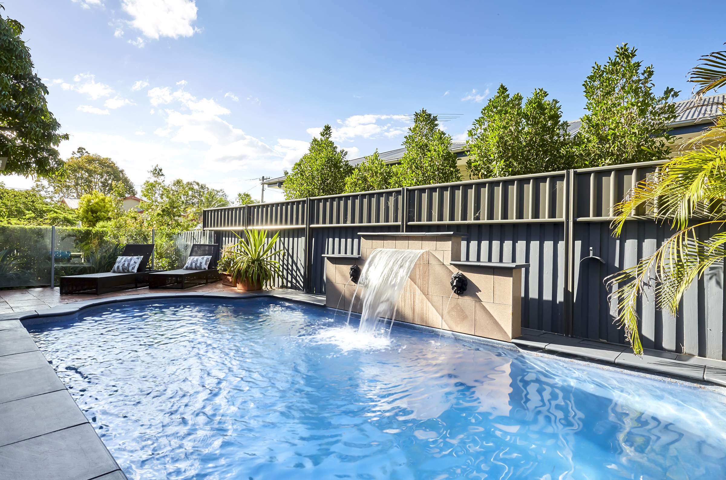
Aerial photography provides a unique vantage point that can significantly enhance property listings. By capturing images from above, real estate agents can showcase not only the property itself but also its surrounding environment, which is crucial for potential buyers. This method allows for a comprehensive view of the property’s layout, landscaping, and proximity to local amenities. The stunning visuals created through aerial photography can evoke emotional responses from buyers, making them more likely to engage with the listing.
Additionally, aerial photography can highlight features that may not be visible from ground level, such as large backyards, swimming pools, or nearby parks. This comprehensive perspective can be particularly beneficial for larger properties or those situated in scenic locations. Furthermore, the use of drone technology allows for high-resolution images and videos that can be used across various marketing platforms, including websites, social media, and virtual tours. The integration of aerial photography into real estate marketing strategies can lead to quicker sales and potentially higher offers.
Drone photography takes aerial imaging to the next level by utilizing advanced technology to capture high-quality images and videos. Drones can fly at various altitudes and angles, providing flexibility in how properties are presented. This capability allows for dynamic shots that can showcase the property in its best light, whether it’s a sweeping view of a sprawling estate or a close-up of architectural details.
For professional aerial images, it is essential to consider the expertise of professional photographers.
Moreover, drone photography can be combined with video footage to create engaging virtual tours. These tours allow potential buyers to experience the property from the comfort of their homes, making it easier for them to envision themselves in the space. The ability to provide immersive experiences can set a listing apart from others, making it more memorable and appealing.
To maximize the effectiveness of aerial and drone photography, it is essential to follow best practices that ensure high-quality results. First, selecting the right time of day for shooting can significantly impact the quality of the images. Early morning or late afternoon provides softer lighting, which can enhance the overall aesthetic of the photographs. Additionally, ensuring that the property is well-prepared for the shoot—such as landscaping, cleaning, and staging—can make a substantial difference in the final images.
Another critical aspect is to work with experienced drone operators who understand the nuances of real estate photography. Professional drone pilots are familiar with local regulations and can navigate airspace safely while capturing stunning visuals. They also possess the skills to edit and enhance images, ensuring that the final product meets the highest standards.
When utilizing drone photography, it is crucial to be aware of the regulations governing drone use in your area. In many regions, drone operators must adhere to specific guidelines set by aviation authorities, including obtaining necessary permits and ensuring that flights are conducted safely. Understanding these regulations not only ensures compliance but also protects the integrity of the property being photographed.
Safety should always be a priority when operating drones. This includes conducting pre-flight checks, maintaining a safe distance from people and structures, and being mindful of weather conditions. By prioritizing safety and adhering to regulations, real estate professionals can effectively utilize drone photography without encountering legal issues.
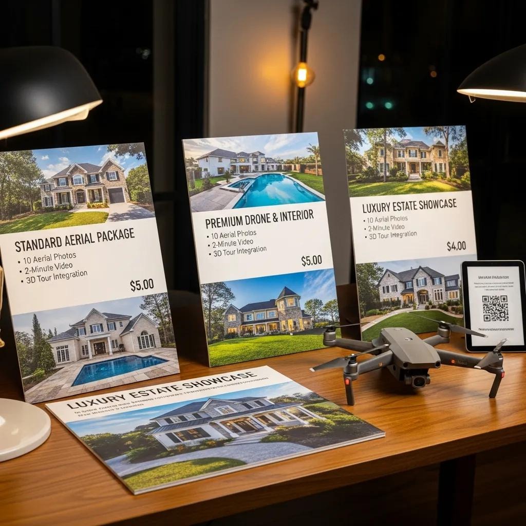
When considering aerial and drone photography for real estate, understanding the pricing structure is essential. Various packages are available, catering to different needs and budgets. Here’s a comparison of typical drone photography packages:
Package Type
Features
Price
Basic Package
10 aerial photos, basic editing
$200 - $300
Standard Package
20 aerial photos, video footage, advanced editing
$400 - $600
Premium Package
30 aerial photos, full video tour, drone mapping
$800 - $1,200
These packages can vary based on the service provider and the specific requirements of the property. It’s advisable to discuss your needs with the photographer to find a package that best suits your marketing strategy.
Several factors can influence the pricing of drone photography services. The size of the property, the complexity of the shoot, and the level of editing required all play a role in determining the final cost. Larger properties may require more time and resources to capture effectively, leading to higher prices. Additionally, if a video tour is included, this can also increase the overall cost.
It’s important to consider the return on investment when evaluating the cost of drone photography. The enhanced visuals can lead to quicker sales and potentially higher offers, making the investment worthwhile for many real estate professionals.
Incorporating aerial and drone photography into real estate marketing strategies can significantly enhance property listings. By providing unique perspectives and high-quality visuals, these technologies can help properties stand out in a competitive market. Understanding the benefits, best practices, and pricing options associated with drone photography is essential for real estate professionals looking to elevate their marketing efforts. As the demand for innovative marketing solutions continues to grow, embracing aerial photography can be a game-changer for real estate agents and sellers alik